The Ultimate Guide to Landslide Prevention: Tips and Techniques for a Secure Environment
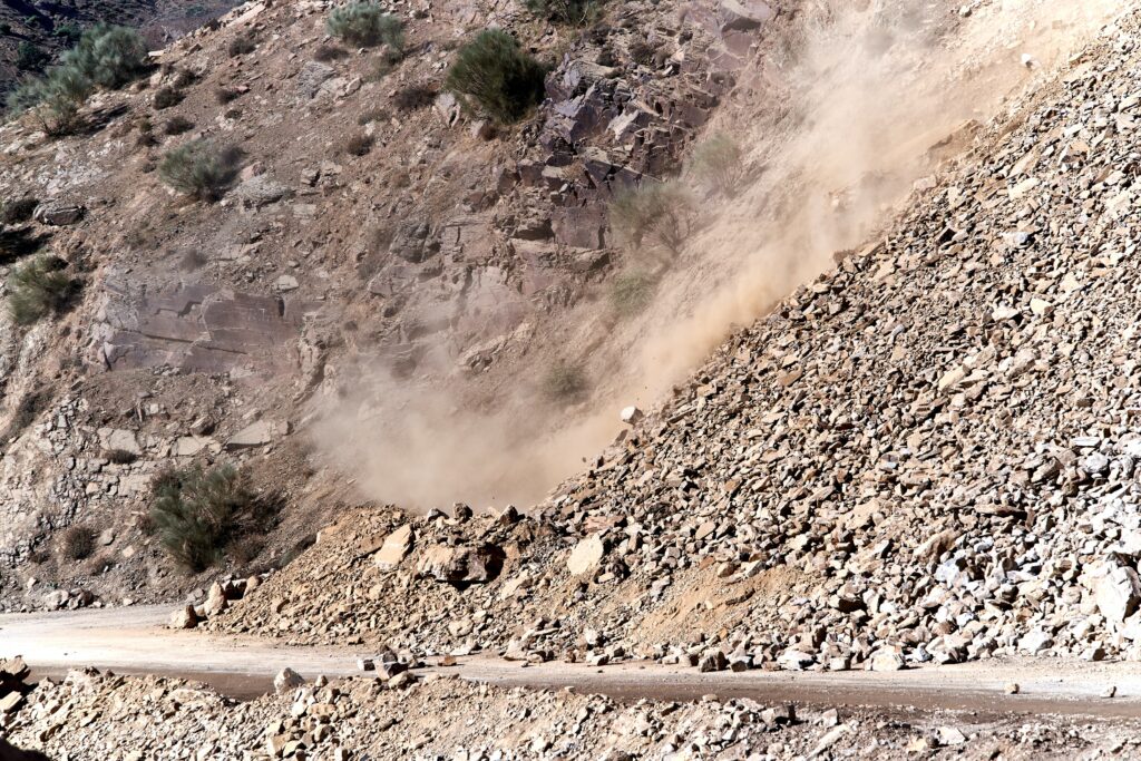
Landslides kill people and cut roads every monsoon in India’s hill states, from Uttarakhand and Himachal Pradesh to the North East and the Western Ghats. Most of the triggers are known: water in the slope, steepness, weak or fractured rock, and human cuts and loads. This guide covers what causes landslides, how to spot a risky slope, the engineering and natural measures that reduce the risk, monitoring and warning, and what to do in an emergency. For a closer look at one engineering option, see landslide mitigation with gabion retaining walls.
Table of Contents
Understanding landslides: Causes and types
A landslide is a mass of rock, soil or debris moving down a slope under gravity. Movements are usually grouped by type, such as falls (rock dropping from a cliff or cut), slides (a block or layer moving along a slip surface), and flows (saturated soil and debris moving like a fluid). Each is set off by some combination of ground conditions, rainfall and human activity.
Ground conditions come first. Slopes in weak or weathered rock such as shale, mudstone and phyllite, or in rock with bedding, joints or faults dipping out of the slope, fail more readily. The steeper the slope, the larger the share of the soil’s weight that acts down it.
Rain is the most common trigger, especially intense bursts or long spells of heavy rain. Water soaking into the slope raises pore water pressure, which reduces the friction holding the soil or rock in place. Slopes that have moved before are particularly likely to move again in heavy rain.
Human activity often tips a slope over. Road and building cuts remove support from the toe, fill and buildings add weight at the top, deforestation removes roots, and blocked or badly designed drains send water into the slope. Poor grading and neglected drainage are behind many failures along hill roads.
The importance of landslide prevention
Landslides block highways, destroy homes and farmland, and bury rivers and water supplies. Preventing a slide, by draining and supporting a slope before it fails, almost always costs less than clearing and rebuilding afterwards. Prevention works best when residents, local authorities and engineers share what they know about the slopes around them.
Assessing landslide risks in your area
Start by finding out how exposed your site is, so that money goes where the risk is highest.
Look for signs of past or current movement: scarps (fresh steps in the ground), tilted trees, poles or walls, cracks in roads and buildings, and bulging at the toe of the slope. Note steep slopes, weak or loose soils and active erosion. Check geological and landslide susceptibility maps; in India, the Geological Survey of India publishes national landslide susceptibility maps.
Then look at water. Note where water ponds or runs fast in heavy rain, where springs or seepage appear on the slope, and where drains overflow. These are the places most likely to fail.
For anything beyond a small private slope, get a geotechnical engineer or the local authority involved. They can run a site investigation and stability analysis and recommend measures.
Landslide prevention techniques: Engineering solutions
Engineering measures either reduce the forces driving the slope or increase the resistance holding it. The common ones are:
1. Slope stabilization: Slope stabilization techniques add structural support to the slope: retaining walls (including gabion walls, which are flexible and free-draining), rock bolts, soil nails and ground anchors. On rock cuts, rockfall barriers and drapery mesh catch or hold falling rock; Ocean has supplied rockfall barriers for landslide prevention in Wayanad, Kerala.
2. Grading and terracing: Regrading flattens the slope or removes weight from the top and places it at the toe, which makes the slope more stable. Terracing breaks a long steep slope into benches, which shortens runoff paths and gives somewhere for drains and planting.
3. Drainage systems: Good drainage is usually the cheapest and most effective measure, because it attacks the main trigger. Surface drains and catch-water drains above the crest keep runoff off the slope; subsurface drains, horizontal drains and geotextile-wrapped trench drains lower the water table inside it. Lower pore pressure means stronger soil.
4. Soil reinforcement: Soil reinforcement techniques build tensile elements into the slope. Geogrids and woven geotextiles reinforce rebuilt or steepened slopes; geocells hold surface soil and vegetation in place on the face.
The right combination depends on the site, so the design should come from a geotechnical engineer’s stability analysis.
Landslide prevention techniques: Natural solutions
Natural and nature-based methods protect the slope surface and manage water, and they work best alongside engineering measures on unstable ground:
1. Vegetation control: Trees, shrubs and grasses bind the surface soil with their roots, take up water, and intercept rainfall so less runs off. Roots reinforce the top metre or two of soil; they do not stop deep-seated slides.
2. Mulching: A layer of straw, wood chips or an erosion control blanket on bare soil softens rain impact and keeps seeds in place until plants establish. Biodegradable coir geotextile is widely used for this on Indian hill slopes, as on Ocean’s Kullu, Himachal Pradesh project.
3. Bioengineering techniques: Soil bioengineering combines live plants with simple structures: brush layering, live fascines, live crib walls. The plants take over the reinforcing role as they grow.
4. Water management: Contour trenches, swales and similar measures slow runoff and spread it out. On a slope that is already marginal, make sure the infiltrated water has a drainage outlet; adding water to an unstable slope can make it worse.
Choose species and methods for the local climate, soil and altitude, ideally with advice from a forester, horticulturist or landscape architect who knows the area.
Best practices for landscaping and land use to prevent landslides
How land is developed and maintained has a large effect on slope stability. On and around landscaped slopes:
1. Avoid slope alteration: Keep cuts and fills to a minimum. Cutting into a hillside removes support, and filling adds load and can block natural drainage.
2. Retain existing vegetation: Keep trees, shrubs and grass on slopes where you can, and replant cleared areas quickly.
3. Limit impervious surfaces: Concrete and asphalt concentrate runoff. Use permeable paving where possible, and make sure runoff from hard surfaces goes into a drain, not onto the slope.
4. Proper drainage design: Collect roof and surface water with gutters, downpipes and lined drains and discharge it well away from the slope. French drains can intercept subsurface water.
5. Erosion control measures: Use retaining walls on steep cuts and erosion control blankets on bare slopes to stop surface erosion that can lead to larger failures.
6. Regular maintenance: Inspect slopes and drains before and after the monsoon. Clear debris and silt from drains, and deal quickly with new cracks, seepage or bulging.
Early warning systems and monitoring for landslides
Monitoring cannot stop a landslide, but it can give enough warning to close a road or move people. The main components are:
1. Geotechnical monitoring: Instruments measure movement and water in the slope: inclinometers for subsurface displacement, piezometers for pore water pressure, and extensometers and crack meters at the surface. Readings that accelerate are the warning sign.
2. Rainfall monitoring: Rainfall intensity, duration and the total over previous days all affect landslide likelihood. Rain gauges, or local weather data, compared against rainfall thresholds for the area, form the basis of most regional warning systems.
3. Remote sensing and satellite imagery: Satellite radar interferometry (InSAR), LiDAR and repeat imagery can detect slow ground movement, new scarps and changes in vegetation over large areas.
4. Community-based monitoring: Local residents are often first to see new cracks, muddy springs or tilting trees. A simple way to report these to the authorities improves any warning system.
5. Emergency alert systems: Warnings only help if they reach people in time. Use SMS, sirens, radio and social media to issue alerts and evacuation orders.
Warning systems need to be designed for local conditions with the district authorities, geotechnical engineers and disaster management agencies.
Emergency preparedness for landslides
Even with prevention, landslides can still happen. If you live or work in a landslide-prone area:
1. Develop an emergency plan: Know your evacuation routes, a safe place to go, and how your household will communicate. Make sure everyone knows the plan and practise it.
2. Assemble an emergency kit: Keep food, water, medicines, a torch, a radio and a first aid kit somewhere easy to grab, and check them before each monsoon.
3. Stay informed: Follow weather warnings, landslide alerts and evacuation orders from the IMD, the district administration and local news. Leave as soon as you are told to.
4. Monitor the surroundings: Watch for new cracks in the ground or walls, tilting trees or poles, rumbling sounds, and sudden changes in stream flow or muddy water. If you see them, move away from the slope and the path of any flow, not into a valley below it.
5. Ensure structural safety: Check your building for cracks and settlement, keep drains around it clear, and have retaining walls inspected.
6. Maintain communication: Agree a meeting point with family and neighbours and keep emergency numbers to hand in case you are separated.
Resources and organizations for landslide prevention and mitigation
Useful sources of information and guidance:
1. United States Geological Survey (USGS): The USGS publishes information on landslide hazards, monitoring and mitigation, with educational material, maps and reports.
2. International Consortium on Landslides (ICL): A global network of landslide researchers and organisations that runs conferences and publishes the journal Landslides.
3. Federal Emergency Management Agency (FEMA): US guidance on landslide risk assessment, emergency planning and recovery.
In India, the Geological Survey of India is the nodal agency for landslide studies and publishes susceptibility maps, the National Disaster Management Authority publishes guidelines on landslide management, and ISRO’s National Remote Sensing Centre has published the Landslide Atlas of India.

source on Google
 How to Choose the Right Pond Liner Material?
 Ocean Hexagonal Woven Double Twisted Gabion Boxes at a Mining Project in Odisha
 Geosynthetics in India’s Tunnel Construction Boom: Zojila, Bullet Train and Beyond